The Long Bridges
From the establishment of Wallis Plains as a convict farming settlement in 1818-19, travel across the low-lying, swampy and flood prone area below what became known as Campbells Hill was problematic for the colonisers. By the mid-1820s, with farm settlement burgeoning further up the valley and access a critical necessity, intending settlers, teamsters, livestock, carts and wagons had great difficulty in traversing the area. During wet weather or floods, movement could be impossible for weeks on end.
The succession of bridges, 1825-1956
The problem was pressing and the solution was obvious: a bridge had to be constructed. The project was one of high priority and a wooden structure was built in 1825 over the most low-lying and most westerly section of the swampy land. At the time this bridge was opened, one of the first of the veterans of the Napoleonic Wars to settle in Maitland had just been granted a holding to farm: the general area was to become known as Veterans Flat.
In either 1833 or 1838 a much longer structure, the first Long Bridge and like its predecessor made of wood, came into being. Built by convicts, it was a toll bridge, with a toll house at its western (Campbells Hill) end. Periodically damaged by flood debris, some of which covered its deck, it frequently needed costly maintenance and replacement of piles, crossbeams, handrail, sleepers and decking. Parts of the bridge were completely rebuilt at times.

Frederick Charles Terry, The Long Bridge, West Maitland, 1855.
Maitland Hospital, opened 1849, is on the right in the background.
The big flood of 1893 washed away 300 feet (90 metres) of this first Long Bridge at the Campbells Hill end. It was quickly rebuilt by the successful tenderer, Samuel McGill, in ironbark. It was 1050 feet (320 metres) long. On 22 May 1894, thousands of people attended the opening ceremony. They made it hard for the dignitaries (who included NSW Premier Sir Geoge Dibbs, Minister for Works Mr W Lyne, the Hon Alex Brown MLA and the Mayor of West Maitland, Mr Henry Crothers) to get to the dais erected in the middle. Maitland people were always enthusiastic about attending major events like these!

The Long Bridge, West Maitland, late 1890s.
Sydney based photographer Henry King took the image.

The Long Bridge, about 1900.
(Picture Maitland, Maitland City Library)
Fifteen years after the new bridge was inaugurated, a tram trestle was added on the northern (Oakhampton) side of the bridge to allow tram services to be extended to Regent St for the benefit of Campbells Hill and Telarah residents.
Between 1935 and 1938 a replacement structure, 875 feet (270 metres) in length, was built in concrete, and on Arbor Day, 1939, school children planted poplar trees on its southern side. Some had been donated by Muswellbrook Shire Council; with further plantings on the northern side of the bridge, the appearance of an avenue was created.

Aerial view looking towards Maitland Hospital before the poplar trees were planted, 1930s.
(Maitland and District Historical Society 2014-3033d)

The poplars along either side of the Long Bridge, about 1943.
The record flood of 1955, which at its peak saw water a metre and a half deep over the deck, caused several Mount Pleasant St houses to be washed off their stumps and dashed to pieces when they struck the bridge. Some had people on their roofs who had to jump onto the bridge as the houses broke up. Several spans of the bridge collapsed.


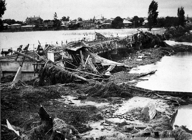


Views of the Long Bridge after the damage caused by the 1955 flood.
Access from the CBD, surrounding residential areas and East Maitland to Maitland Hospital was cut for a time and westward travel on the vital New England Highway was rendered impossible. A temporary road was quickly constructed immediately to the north across the floodway while a new bridge was constructed in concrete and steel. This structure was opened in August 1956, 18 months after the flood.
In 2018, old and apparently decaying, the last of the poplars were removed after a council decision which promoted negative comment in some quarters. The poplars had become a feature of the local environment and in the minds of some people they were an important part of the area’s heritage and worthy of protecting.
Current concerns
Early in the present century, concerns arose on Maitland’s local emergency management committee about the fitness of the bridge for evacuation purposes. In big floods, but even in floods smaller than the one that struck in 1955, the Long Bridge is likely to be the last route out of Lorn, the CBD, Horseshoe Bend and the streets adjoining High St.
If it becomes untrafficable through water flowing over the deck, or if damage wrought by debris compromises the Long Bridge’s structural integrity, people who have not evacuated will be stranded and unable to escape unless they can be rescued by floodboat or helicopter. It is distinctly possible that, if people are slow to respond to calls to evacuate (a common phenomenon in flood-liable communities), there will be insufficient boats and helicopters to get everybody out. Those who remain unevacuated could be in grave danger.
The solution, one day, will be a new Long Bridge. It will probably begin at a higher level than the current bridge at the end of a gradually rising western High St and end higher again than the present bridge does at Campbells Hill. Such a bridge would help ensure that everybody in the older flood-prone parts of Maitland would be able to escape a developing flood in their own vehicles provided, of course, that they did so in an appropriately timely manner and the roads were not already flooded.
References
Hunter, Cynthia, Out of the Closet: Maitland’s Water Stories, Maitland City Heritage Group, Maitland City Council, 2006, pp.19-22.
Keys, Chas, ‘Our past: Long Bridge the answer to swampy land to Maitland’s west’, Maitland Mercury, 18 April 2021.
Long Bridge Album, Picture Maitland, Maitland Libraries.
‘Reminiscences of the old Long Bridge’, Maitland and District Historical Society Bulletin, 21/3, August 2014, pp. 8-9.
Working plans for the Long Bridge, 1930s to 1955, Maitland Libraries, LIB2022.022a to p, digital copies available on Collections Maitland.
Walsh, Brian and Archer, Cameron, Maitland On the Hunter, second edition, CB Alexander Foundation, Paterson, 2007.