Nowland’s Gap
Crossing the Blue Mountains to the interior of New South Wales was a major challenge to the early colony. It took 25 years after the founding of the penal settlement at Sydney before W.C. Wentworth, William Lawson and Gregory Blaxland found a route via Mt Victoria which held the promise of opening up the vast inland to agricultural settlement. But this route was severely problematic: the grades on the western flank of the Blue Mountains were precipitous and were dangerous for horses and drays to navigate.
The search for a route out of the Hunter Valley
When during the 1820s pressure built to settle the interior of New South Wales for farming, the search for a better route across the Great Dividing Range became critical. An early crossing point, used by explorer Ben Singleton, was over the Liverpool Range at Dartbrook Pass near the source of Dart Brook and west of today’s Murrurundi. Like the Mt Victoria route this route was difficult, as Patricks Plains settler William Nowland related in a letter to the Sydney Morning Herald in January 1861 when he described his finding of a better route in 1827. Nowland wrote:

[In this endeavour Nowland also had to contend with escaped convicts operating as bushrangers.]
Nowland went on to explain that he

The importance of Nowland’s crossing point
This saddle, now called Nowlands Gap, was more than 600 feet (180 metres) lower than the Dart Brook and Mt Victoria crossing points but, more importantly, its gradients were much milder. Immediately it was the preferred route to the inland and the north. It strengthened Maitland’s role as the jumping-off point for travel to places beyond the Hunter Valley and was a major stimulus to the inns and stores of Maitland as settlers and teamsters travelled through in numbers on their way up and out of the Hunter.
As the road network developed, no other location supplanted Nowlands Gap for ease of movement to the west, and it thus became the major gateway to the inland and the north. The convict-built Great North Road (later the basis for the New England Highway) was to cross the Liverpool Range above Murrurundi at the point favoured by Nowland.

Nowland’s Gap sign on the New England Highway.
William Nowland
William Nowland (1804-84) was the son of convicts who had arrived in Sydney in 1790 in the Second Fleet. He developed large holdings on the Liverpool Plains and near Glen Innes in addition to his property (Rosedale) at Camberwell in the Patricks Plains area where he built a hotel and shops and helped establish a school. With his brothers Henry and Edward he was involved in the coach transport business carrying mail, goods and passengers through a large area of northern New South Wales and into Queensland.

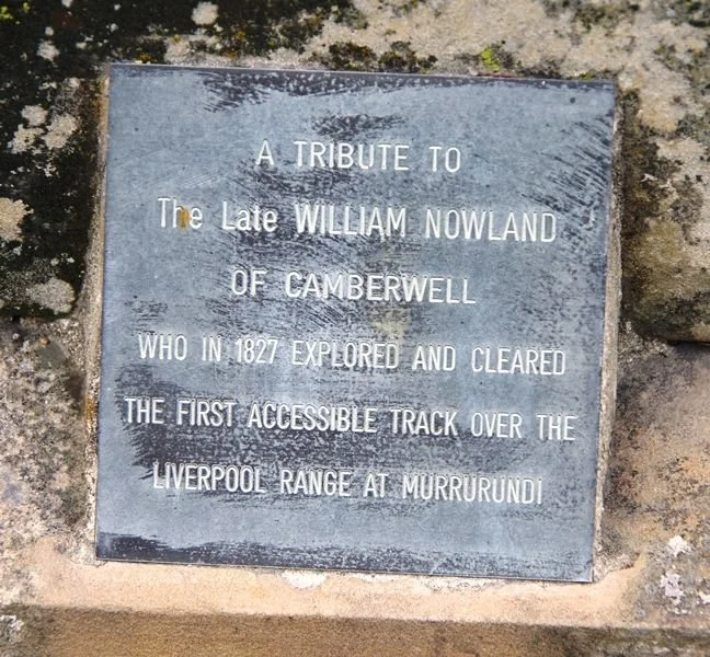
Nowland’s gravestone and (right) the plaque at the base of the gravestone, Camberwell Anglican Church Cemetery.
(Find-a-grave and Monument Australia)
Nowland’s ‘discovery’ of Nowlands Gap and his clearing of a track over it was a major contribution to the development of New South Wales.
He also developed several farming properties and played significant roles in the transport industry and the establishment of the village of Camberwell (originally Falbrook), up the valley from Singleton.
References
Keys, Chas, ‘Our past: challenge of finding a passage to the interior of NSW’, Maitland Mercury, 13 May 2021.
Sydney Morning Herald, 23 January 1861, p3.